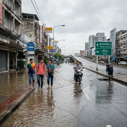
A new bilingual web platform aggregating flood data from more than a dozen official and public monitoring sources has been launched to track water levels and road closures across Bangkok.
The service, named Floodboard, collates real-time information from municipal departments, transport bodies, and direct public reports into a single digital map. Designed to operate free of charge in both English and Thai, the tool addresses the persistent difficulty residents face when navigating fragmented government updates during the monsoon season. For British expatriates living in the capital or considering a move to flood-prone provinces, the utility provides a consolidated method to assess travel safety, property accessibility, and neighbourhood disruption.
Consolidated Monitoring for Flood Conditions
The platform compiles data from more than 12 independent channels. These include the Bangkok Metropolitan Administration’s Drainage Department, the Department of Highways, the Thai Meteorological Department, the ThaiWater portal, and traffic tracking networks such as iTIC and Longdo.
It was developed by a three-person Polish engineering team resident in Thailand. Software developer Mateusz Gniadek led the development alongside Hua Hin-based entrepreneur Patryk Tylza and audio systems engineer Karol Bernacki.
The software architecture relies on redundancy models typically used in sound engineering to prevent server failure during traffic spikes. Heavy rain triggers sudden surges in web queries. By distributing server loads, the interface remains operational when weather conditions worsen rapidly.
Users can view flooded thoroughfares, check recorded water depths, observe ongoing traffic tailbacks, and pinpoint locations where stranded motorists or residents require assistance.
The Fragmented Information Landscape
Accessing reliable civic information in Thailand has long posed operational challenges for foreign nationals. Most municipal updates are issued through dispersed channels that cater almost exclusively to Thai speakers.
The primary municipal complaint application, Traffy Fondue, processes thousands of localised drainage grievances each week. However, understanding its geographic distribution requires navigating an interface that often lacks full English localisation. Crucial warnings from district offices are frequently shared as static text images on social media accounts rather than machine-readable alerts.
British expatriates must routinely consult multiple disparate channels to establish whether a standard commute remains viable. This fragmentation increases the likelihood of vehicles entering deep standing water, leading to mechanical failures and costly recovery charges. Floodboard circumvents this by translating and plotting multi-agency feeds onto an interactive map accessible via standard mobile browsers.
Data Integration and Verification
To prevent the spread of inaccurate user submissions, the platform applies a verification layer to all crowdsourced content.
Members of the public can submit requests for assistance or log submerged roads directly from their mobile devices. Each submission requires precise geographic coordinates, a timestamp, and photographic evidence of the water level against local landmarks or kerbs. These public submissions are cross-referenced with institutional data provided by the Department of Highways and municipal drainage stations before a status marker changes on the public interface.
Streets are categorised by transit viability. Markers indicate whether a route remains navigable for standard passenger saloons, high-clearance four-wheel-drive vehicles, or heavy goods lorries only.
This level of detail is particularly critical for expatriates unfamiliar with the specific topography of low-lying Bangkok neighbourhoods. In many sub-districts, a minor rise of twenty centimetres can render a residential side street impassable within half an hour.
Commuting and Transport Implications
For British professionals commuting between suburban residences and commercial districts, road submergence represents a recurring financial and personal risk.
Vehicle damage caused by driving through deep water is rarely fully covered by baseline Thai third-party insurance policies. Comprehensive policies, often referred to locally as Type 1 cover, typically include flood damage clauses, but insurers frequently reject claims if the driver is deemed to have entered a visibly flooded street wilfully. Hydrostatic engine lock, caused by water intake through the air filter, usually requires a complete engine rebuild.
Private motor vehicles are not the only transport mode affected. App-based taxi drivers frequently cancel bookings to outer neighbourhoods when rain warnings are issued, leaving commuters stranded in downtown office buildings.
The new tracking service allows individuals to monitor specific choke points, such as the low-elevation access roads feeding the Expressway network and the entryways to major mass transit hubs. If an underpass begins to collect water, drivers can adjust their route before joining unmoving queues on elevated motorways.
Residential and Tenancy Risks
Drainage conditions across Bangkok vary significantly by district and elevation. The capital rests on alluvial soil near sea level, and broad variations in road elevation mean that one end of a residential soi can remain completely dry while the opposite end accumulates half a metre of floodwater.
British renters and prospective property buyers frequently fail to inspect neighbourhood drainage capacity during the dry season. A property viewed in February offers little indication of its accessibility during the peak precipitation months of September and October.
Expats considering long-term lease agreements in areas such as Bang Na, Lat Phrao, and low-numbered Sukhumvit sois can use the historical and live map data to audit local drainage behaviour.
Ground-floor car parks in older apartment developments and modern townhouse complexes are especially susceptible to flash flooding. When municipal drainage canals exceed capacity, backflow through street-level stormwater drains occurs swiftly. Access to continuous water level monitoring enables tenants to move parked vehicles to elevated multi-storey facilities before ground access is severed.
Emergency Assistance and Civic Reporting
Beyond transit monitoring, the platform acts as an unofficial dispatch directory during acute weather crises.
Users can lodge requests for non-critical evacuation, vehicle recovery, and physical assistance. When municipal emergency lines become congested, community rescue foundations—such as the Ruamkatanyu Foundation and the Poh Teck Tung Foundation—often use open-source mapping data to prioritise their responses. The inclusion of English-language reporting fields allows non-Thai residents to communicate specific needs to these volunteer units without relying on intermediaries.
The service is intended as a supplementary tracking utility rather than a substitute for state civil defence directives. British nationals encountering life-threatening emergencies must continue to contact standard emergency lines, including the Tourist Police on 1155 or the national emergency number on 191.
Current Municipal Context
Bangkok's local government recently reduced the number of active flood disaster surveillance zones from 50 districts to 29.
The reduction follows the implementation of localised pumping measures and clearing operations by the Bangkok Metropolitan Administration along major arterial canals. Despite these administrative improvements, localised flash flooding remains common due to intense tropical downpours overwhelming ageing drainage networks.
Flight cancellations and transit delays also continue to affect key transport hubs during peak storms. Travellers making their way to Suvarnabhumi or Don Mueang airports are advised to verify access routes several hours before departure.
Expatriates living throughout the metropolitan area are advised to bookmark the Floodboard tool, check the data alongside daily bulletins issued by the Thai Meteorological Department, and plan secondary travel routes whenever heavy rain coincides with high tides along the Chao Phraya River.
Source: thethaiger.com
Reviewed by the Thailand Guide Editorial Team • Last reviewed: 30 September 2026
This page is provided for general information only. While we aim for accuracy, details can change — please verify anything important independently before relying on it.